The journalists from Mongabay and CNN behind the recent investigation into the activity of the Chinese deep-sea mining fleet discuss the idea, the data-centric approach, the methodology, and the steps they followed for a collaborative investigation that lasted one year and was carried out with the support of the Pulitzer Center.
Featured image: Courtesy of Mongabay
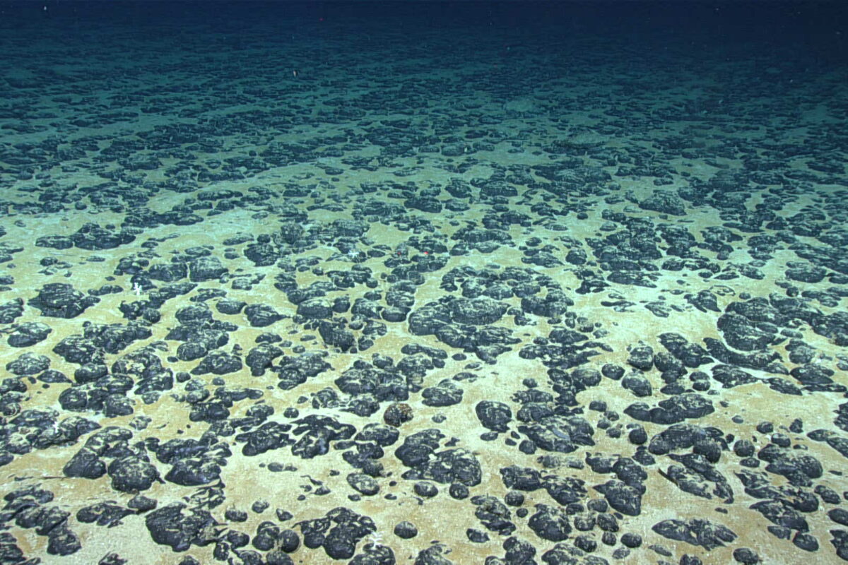
Access to rare earth metals has created a new race that reaches even to the “final frontier” of Earth, the deep-sea floor, where polymetallic nodules that contain precious elements like manganese, nickel, copper and cobalt are located. But in this competition between China and the USA, Beijing may be utilizing its fleet to do more than just deep-sea research, according to a joint investigation conducted by Mongabay and CNN, with the support of the Pulitzer Center.
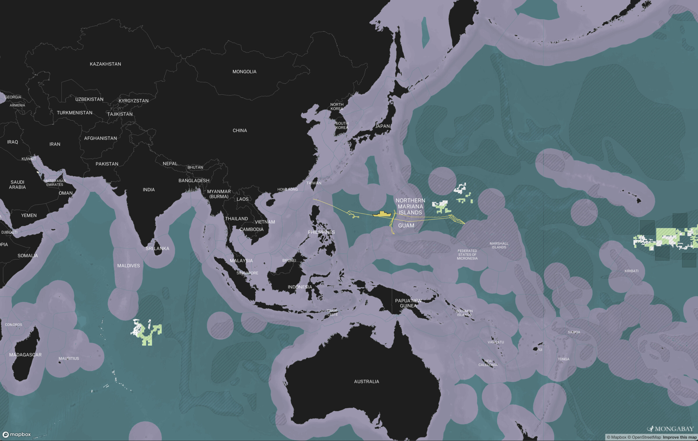
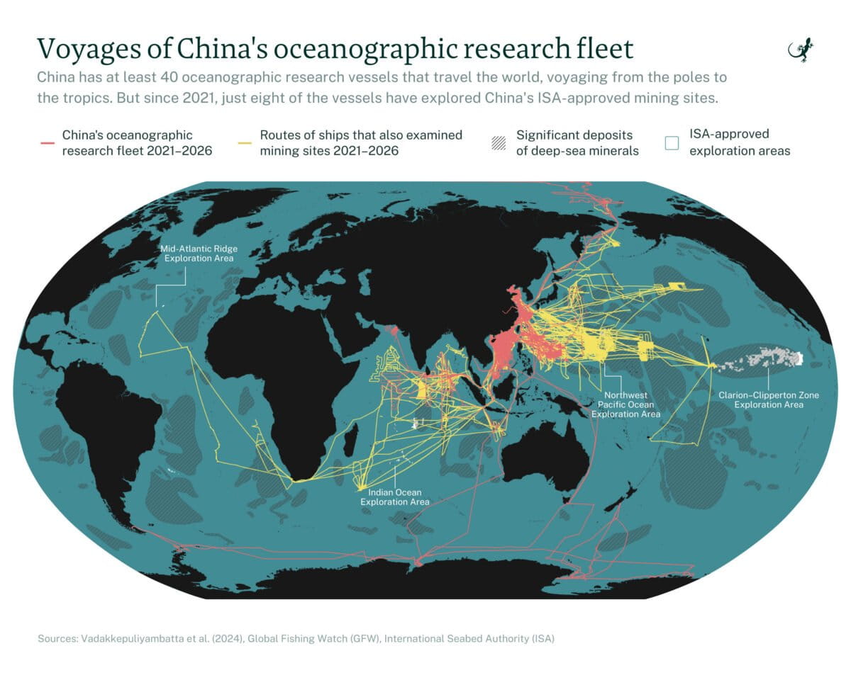
The Chinese deep-sea mining fleet investigation tracked the movements of eight research vessels between January 2021 and January 2026 and found out that they spent little time in the exploration areas and made extensive trips in militarily strategic waterways. Using data provided upon request by the Pulitzer Center from Marine Traffic and the open and freely available data on Deep Sea Mining Watch, the journalists noted that the eight ships that they tracked were visiting Chinese naval bases, were turning off their AIS systems, and encroached in other countries Exclusive Economic Zones (EEZ).
iMEdD talked to the authors behind this joint investigation, Elizabeth Alberts, Senior Staff Writer at Mongabay and Pulitzer Center’ Ocean Reporting Network (ORN) Fellow, and Kara Fox, Senior Reporter at CNN.
The birth of an investigation
The idea of examining the links between deep-sea mining exploration and the military sector actually began during Elizabeth Alberts’ fellowship at the Pulitzer Center’s Ocean Reporting Network (ORN).
“It was because of that base knowledge and because of a lot of the knowledge that we had already gained from sources about potential dual-use of some of the key players and the key actors in this industry that we decided to look a bit deeper,” says Fox. “We were interested in China for a number of reasons, although that wasn’t the initial focus of where we started with our investigation,” she explained, adding, “Investigations that have many, many months and many different leads will take you to many different places. Οnce we started looking at China, it felt like an obvious place for us to continue looking”.
The two journalists began following the activities of Chinese vessels when Beijing signed a memorandum of understanding (MoU) with the Cook Islands, an island nation in the South Pacific, on seafloor exploration in February 2025.
The signing of the MoU marked a “geopolitical shift,” Fox says, leading the journalists to explore other references to the “dual-use” nature of Beijing’s vessels. They then came across a 2024 study by the Center for Strategic & International Studies (CSIS) on China’s oceanographic vessels in the Indian Ocean. Fox explains that this is where the first steps in their methodology for the story began.
The journalists say that, in its research, CSIS had found that across dozens of ships it had examined, China seemed to be using those vessels for military purposes as well: “And what they [CSIS] had found over dozens of ships that they had looked at was that China was indeed using or appeared to be using those vessels for military uses as well, not just research. And so we had read their work. We engaged with them on some of their methodology. And it was similar to some of the methodology that we had started playing around with ourselves.”
Explaining their focus on China, Alberts explains that they “wanted to look at China because China has the largest lead in the world. It has the largest number of exploration contracts through the International Seabed Authority.” She also points out that “the areas the US is looking to mine under its own authority are going to be even bigger.”
Methodology and key parameters
Identifying the right methodology is one of the most important steps before beginning a long-term investigation. For Alberts and Fox, as they explain, the first steps in this process were based on research by CSIS and other experts on the topic, such as Darsana Baruah, a specialist in Indo-Pacific maritime security and strategy at the International Institute for Strategic Studies (IISS), and Raymond Powell of SeaLight, a non-profit organization focused on China’s maritime military activities.
The large scale of Beijing’s oceanographic fleet was one of the first challenges in the investigation, as not all vessels were equally relevant. “It was a bit of a challenge at first finding exactly which of China’s very large oceanographic fleet was working specifically only on deep-sea mining,” Fox says.
“What we ultimately did was look at Chinese documents along with our Chinese-speaking colleagues, as well as what was publicly available and also what was available from the China Maritime Institute,” she says.
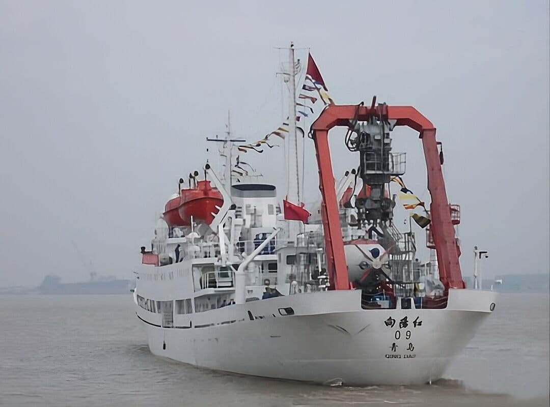
This resulted in a list of vessels reportedly conducting research in areas under the International Seabed Authority (ISA), with the investigation ultimately focusing on eight of them.
“So of course, with any big project, you start with a lot of data and then you whittle it down and whittle it down. We got five years of data from those specific vessels. In our piece, we tracked 8, but I think when we originally started, we had something like 20. And we had to, from those five years from Marine Traffic, apply very specific parameters to what we were looking at. So we decided to look at whether they had spent any time in the Chinese licensed areas,” Fox says, explaining that vessels were included if they were found either within a licensed area or within a 20-nautical-mile buffer of it, and vessels that loitered around ISA areas or Exclusive Economic Zones (EEZs).
In these cases, the journalists reviewed local media reporting to determine whether the Chinese vessels’ passages had taken place with the consent of local authorities.
“We were also looking at news articles to figure out if there was something mentioned in the news about Chinese vessels in Palau’s EEZ, and whether that had been brought up,” Alberts explains.
The investigation also considered whether these vessels had visited Chinese naval installations.
Data and “spoofing”
The journalists’ research placed geospatial data from vessels’ AIS (Automatic Identification System) at the centre of its methodology, as the system transmits information on a ship’s coordinates.
Access to this data was made possible in part with support from the Pulitzer Center. “They gave us a lot of data support in the early parts of the investigation, getting these vessel tracks of interest. [It also] helped us connect with Marine Traffic, who initially supplied a lot of data to us,” Alberts said.
However, AIS data is not flawless. A common practice in covert maritime activity is “spoofing” — the deliberate manipulation of AIS signals to transmit false information about a vessel’s location, identity, or speed.
“Another element that we had looked at, where we were limited by some of the marine traffic data, was whether or not the ships appeared to do any spoofing or turned off their AIS data […] So we reached out to Starboard Maritime Intelligence, who specialize in AIS,” Fox said, adding that the team also contributed another layer of data, namely “whether or not any of these vessels had been moving across cables, undersea cables.”
“One thing that was really crucial to this reporting was when Elizabeth and I had found specific routes that not only were routes that looked kind of interesting, but also fit all of the other parameters that we’ve just talked about. We screenshot and took those routes to our experts. And that was really helpful because sometimes our experts had conflicting opinions on them. It was helpful for us to take a step back and say, maybe this isn’t the place that we need to be looking and maybe we need to look somewhere else,” Fox says.
Challenges and limitations
The journalists faced a number of significant challenges in a data-heavy investigation set against an ever-shifting geopolitical environment.
For Alberts, the refusal of Chinese companies and relevant ministries to respond was one of the most difficult parts of the months-long effort. That’s quite unfortunate because that’s a bit of a hole in the reporting — one we wish we could have filled, but we knew that was going to be difficult anyway,” she said. “We did get a response from the Ministry of Foreign Affairs, but otherwise we didn’t get any responses from the companies, the institutions that were doing this work,” she added.
Fox, meanwhile, highlighted the complexity of a long-term investigative process during which new developments were constantly unfolding. “For example, during the time of our investigation, Trump signed an executive order accelerating deep sea mining from the US side. That obviously added an additional element of interest and tension,” she went on to explain.
Tips and tricks
By Kara Fox & Elizabeth Alberts
- Never publish in a vacuum. Engage your preliminary findings with multiple subject-matter experts to fact-check data and uncover new leads. If experts offer conflicting interpretations of your data, return to the “drawing board” to re-evaluate your thesis. And don’t be afraid to “kill your darlings.” For example, it is far better to have a finding challenged — or even dropped — pre-publication than to face a correction later.
- If a lead remains shrouded in conflicting opinions, be prepared to walk away.
- Don’t wait for a finished draft to reach out. Engage experts during the hypothesis stage to build rapport and set the tone for your investigation. By the time you have specific data points to highlight, your sources will already be invested in the project. This makes them much more likely to offer the deep-dive feedback needed for a breakthrough.
- Seek a global and multidisciplinary panel. For this reporting, we consulted over a dozen experts across several continents, balancing naval intelligence with academic rigor to ensure a 360-degree view.
- You don’t need to be a data scientist to produce data-driven journalism; you just need to be a good collaborator. Partner with colleagues who can support your technical needs while mentoring you through the process. We also suggest tools over code.
- If complex software feels daunting, start with user-friendly platforms. While we utilized QGIS after training with the Pulitzer Center’s data team, tools like Kpler and Google Earth offer powerful, accessible alternatives for those who aren’t ready for heavy coding or massive datasets. Also, platforms like Global Fishing Watch and Deep Sea Mining Watch are very accessible tools that can be used for investigations. Start where you feel capable, then scale your technical ambitions as the investigation grows.