
The first quarter of 2019 saw more acres burned than any other first calendar quarter of the last 17 years, while in March 2019, Greece recorded the highest number of out of fire season fires since 2000. The analysis of data obtained from Greece’s fire service suggests that the country battles wildfires all year long and not only, as many would think, during the summer.
Editor’s note: the metric this article uses
to measure burned areas is stremmata.
One Greek stremma is equal to 1000
square meters. Stremmata is the plural
of the noun
In 2019, a total of 9,500 forest fires were recorded across Greece by the fire service, an additional 1,500 compared to 2018, according to data obtained from Greece’s fire service’s annual fire reports, while early 2020 data published by the European Forest Fire Information System (EFFIS) indicates that the amount of land scorched by wildland fires is larger than the previous year.
The worst hit prefecture in terms of number of fires is Elis (672), followed by Larissa (590) and Messenia (532).
| Νομός | Πυρκαγιές |
|---|---|
| ΗΛΕΙΑΣ | 672 |
| ΛΑΡΙΣΑΣ | 590 |
| ΜΕΣΣΗΝΙΑΣ | 532 |
| ΠΕΛΛΑΣ | 523 |
| ΑΙΤΩΛΟΑΚΑΡΝΑΝΙΑΣ | 440 |
| ΚΑΡΔΙΤΣΑΣ | 374 |
| ΕΒΡΟΥ | 335 |
| ΑΧΑΙΑΣ | 289 |
| ΗΜΑΘΙΑΣ | 277 |
| ΡΟΔΟΠΗΣ | 256 |

However, the most affected prefecture for 2019 in terms of acres burned is Evia, with more than 35,500 stremmata having been consumed by flames. Of these, about 30,000 were burned in the large fire of August 13 that broke out in central Evia, in the municipality of Dirfys – Messapia, where a dense pine forest was devoured by blaze, part of which was a Natura 2000 candidate.
Following Evia, the second worst hit prefecture by acres burned is that of Larissa (31,630 stremmata), succeeded by Pella (9,053). The prefectures with the largest forest areas lost to fire are Evia (29683.10), Pella (7974.80) and Zakynthos (6,222.0).
| Νομός | Στρέμματα |
|---|---|
| ΕΥΒΟΙΑΣ | 35546.8 |
| ΛΑΡΙΣΑΣ | 31630.1 |
| ΠΕΛΛΑΣ | 9053.9 |
| ΚΟΖΑΝΗΣ | 7375.0 |
| ΖΑΚΥΝΘΟΥ | 7124.2 |
| ΛΑΚΩΝΙΑΣ | 6253.2 |
| ΙΩΑΝΝΙΝΩΝ | 5968.2 |
| ΒΟΙΩΤΙΑΣ | 4763.7 |
| ΑΤΤΙΚΗΣ | 3972.8 |
| ΚΟΡΙΝΘΙΑΣ | 3672.1 |
| ΦΘΙΩΤΙΔΑΣ | 3303.9 |
| ΚΑΡΔΙΤΣΑΣ | 3157.9 |
| ΚΙΛΚΙΣ | 2897.9 |
| ΗΛΕΙΑΣ | 2595.3 |
| ΚΥΚΛΑΔΩΝ | 2384.4 |
| ΕΒΡΟΥ | 2073.1 |
| ΑΙΤΩΛΟΑΚΑΡΝΑΝΙΑΣ | 2019.5 |
| ΦΛΩΡΙΝΑΣ | 1907.4 |
| ΠΙΕΡΙΑΣ | 1760.4 |
| ΠΡΕΒΕΖΗΣ | 1689.3 |
| ΞΑΝΘΗΣ | 1557.7 |
| ΚΑΣΤΟΡΙΑΣ | 1224.2 |
| ΗΜΑΘΙΑΣ | 1180.6 |
| ΔΡΑΜΑΣ | 1173.0 |
| ΜΕΣΣΗΝΙΑΣ | 1143.6 |
| ΑΡΤΑΣ | 1083.9 |
| ΡΟΔΟΠΗΣ | 1039.2 |
| ΚΕΦΑΛΛΟΝΙΑΣ | 1002.5 |
| ΔΩΔΕΚΑΝΗΣΩΝ | 995.9 |
| ΣΑΜΟΥ | 985.1 |
| ΜΑΓΝΗΣΙΑΣ | 973.3 |
| ΘΕΣΣΑΛΟΝΙΚΗΣ | 899.1 |
| ΤΡΙΚΑΛΩΝ | 882.4 |
| ΣΕΡΡΩΝ | 855.6 |
| ΑΧΑΙΑΣ | 826.4 |
| ΘΕΣΠΡΩΤΙΑΣ | 820.0 |
| ΕΥΡΥΤΑΝΙΑΣ | 760.7 |
| ΦΩΚΙΔΟΣ | 701.9 |
| ΛΕΣΒΟΥ | 661.9 |
| ΑΡΓΟΛΙΔΟΣ | 620.2 |
| ΑΡΚΑΔΙΑΣ | 593.5 |
| ΓΡΕΒΕΝΩΝ | 581.1 |
| ΚΕΡΚΥΡΑΣ | 556.4 |
| ΡΕΘΥΜΝΟΥ | 506.3 |
| ΚΑΒΑΛΑΣ | 483.0 |
| ΧΑΛΚΙΔΙΚΗΣ | 393.1 |
| ΧΙΟΥ | 339.5 |
| ΗΡΑΚΛΕΙΟΥ | 279.1 |
| ΧΑΝΙΩΝ | 257.5 |
| ΛΑΣΙΘΙΟΥ | 194.1 |
| ΛΕΥΚΑΔΟΣ | 38.8 |
What kind of areas are burned
In February and March of 2019 more fires broke out than in July and August
In 2019, more than 43,000 stremmata of forest land and 34,000 of woodland area (forest expanses) were burned, followed by agricultural and grassland areas.
Α forest, according to par. 1 of Article 3 of Law 998/79, is the organic whole of wild plants with woody trunk on the necessary area of ground which, together with the flora and fauna coexisting there, constitute by means of their mutual interdependence and interaction, a particular biocoenosis (forest biocoenosis) and a particular natural environment (forest-derived).
Α forest expanse, as defined in par. 2 of the same Law, exists when, in the abovementioned whole (forest), the wild woody vegetation, either high or shrubbery, is sparse.
Α Grassland, is in-between a forest and an agricultural land. Grasslands are not cultivated systematically, they are covered in wild woody plants to a lesser extent and they do not meet the requirements to be classified as forest areas. However, mountain grasslands enjoy a protected status under forest legislation and are considered as forest areas.
Crop residues result from agricultural activities and fruit harvesting. Farmers are accustomed to burning farm waste, but when safety rules are not followed, fires spread to nearby areas. The majority of fires in the winter months are linked to fires that got out of control after being set by farmers to burn crop waste.
Swamps are areas of land flooded with stagnant freshwater and typically vegetated with reeds.
A grove is a small forest located in or near residential areas.
Garbage dumps are sites for the disposal of waste materials.
Agricultural land is land exclusively devoted to agriculture.
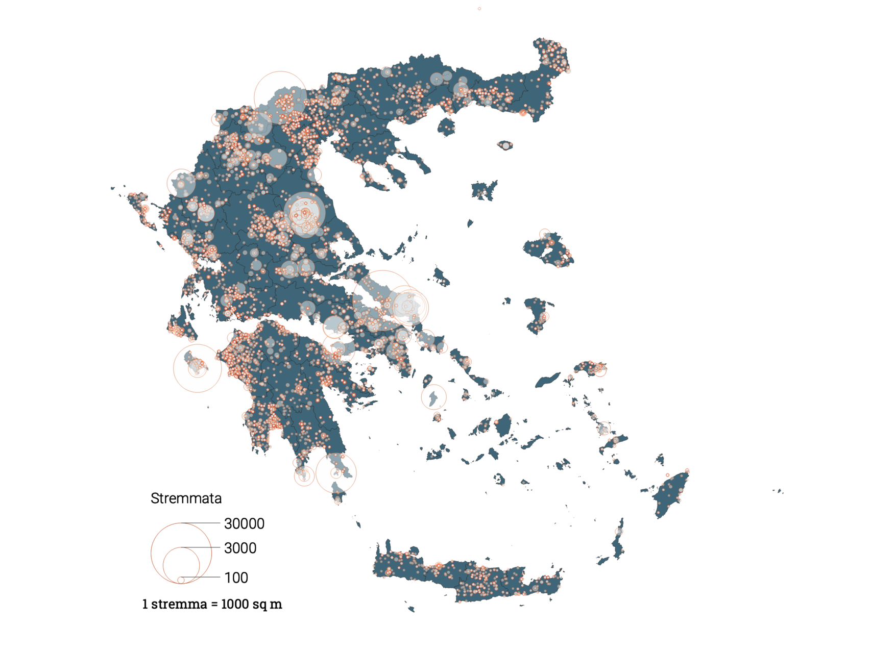
Interactive fire map with 2019 fires across greece
The map above shows forest fires per type of area destroyed across Greece, as recorded by the fire service. The size of the circle reflects the total area burned by specific recorded incident when compared with the other fire instances. However the size of the bubble does not represent the actual area that was burned.
Maps were created using Google’s Geocoding service. Either due to missing data on precise location or due to Google’s inability to locate certain areas with absolute accuracy, some hotspots have been placed on the map approximately.
Record fires per day in 2019
March 2019: Worst month for out of fire season wildfires in 20 years
More fires broke out in February and March than in July and August.
Total fires per month and type of area
The last twenty years (2000-2019) had never seen as many fires during winter/spring as the ones that raged in March 2019, when 1,912 fires scorched more than 13,000 stremmata of land, i.e. almost 8% of the total area burned that year.
August comes second in place with 1187 fires, followed by September (1174) and February (1067). In March, most fires occurred in Pella (156 incidents), followed by Elis (88). In August, the majority of fires erupted in Messenia (91) and Elis (90). In September, Larissa was the worst-hit prefecture (140), followed by Elis (88).
In addition, as shown in the diagram below, in the first quarter of 2019, the burnt forest area was the second largest on record since 2000 (comparing the first quarter of each year). Last year, in particular, 5.190 stremmata of forest area and 1292 of forest were burned. In 2001 alone, more land was burned during the first quarter of that year (10,567 stremmata of woodland area and 4,131 stremmata of forest). Also, in the first quarter of 2019, 2,985 stremmata of agricultural land were burned, a 383% increase compared to the first quarter of the previous year and a 232% increase compared to the average annual farming acreage burned (average of the first quarter between the years 2000-2019).
However, in 2019, 10,584 less stremmata of agricultural land were burned compared to 2018, but the number of stremmata lost to crop residue burning rose by 2,663.
Type of area burned in the first quarter of each year between 2000 and 2019.
More fires but less burned acres
Even though the number of fires for 2019 was higher than the previous year, 31,000 less stremmata were burned in total. At the same time, a total of 17,000 less stremmata of forest were engulfed in flames in the same year, but the number of stremmata of burned forest expanse increased by 1,075.
| Έτος | Δάσος | Δασική Έκταση | Άλσος | Χορτ/κές Εκτάσεις | Βάλτοι | Γεωργικές Εκτάσεις | Υπολλείματα Καλλιεργειών | Σκουπιδότοποι | Σύνολο Στρεμμάτων |
|---|---|---|---|---|---|---|---|---|---|
| 2000 | 465770.6 | 411667.0 | 263.4 | 213752.5 | 13025.7 | 222711.6 | 227231.4 | 5428.3 | 1559850.5 |
| 2001 | 25215.5 | 83046.2 | 384.4 | 83127.0 | 9863.7 | 39745.3 | 181598.1 | 5274.0 | 428254.2 |
| 2002 | 2952.0 | 16766.2 | 55.2 | 13993.9 | 5416.5 | 14021.9 | 26538.1 | 2078.4 | 81822.2 |
| 2003 | 4906.2 | 22105.2 | 164.8 | 25428.3 | 1993.3 | 14537.9 | 14669.6 | 961.6 | 84766.9 |
| 2004 | 11729.0 | 32664.4 | 75.3 | 33884.6 | 4332.3 | 13309.8 | 36561.6 | 2010.4 | 134567.4 |
| 2005 | 12640.2 | 26632.2 | 37.5 | 15753.0 | 3237.3 | 14810.9 | 14405.3 | 1217.8 | 88734.2 |
| 2006 | 7933.3 | 48971.8 | 58.9 | 20420.2 | 3545.1 | 55967.9 | 14972.3 | 1020.3 | 152889.8 |
| 2007 | 651585.7 | 836887.5 | 644.3 | 296210.4 | 29786.2 | 660373.2 | 167600.5 | 1134.4 | 2644222.2 |
| 2008 | 105044.1 | 119281.4 | 137.8 | 48019.7 | 8405.5 | 49379.4 | 55232.4 | 1461.5 | 386961.7 |
| 2009 | 61703.8 | 149200.4 | 87.5 | 119675.1 | 14805.1 | 59844.9 | 40010.8 | 5418.7 | 450746.3 |
| 2010 | 16775.6 | 44470.1 | 43.0 | 39604.8 | 5846.8 | 29680.3 | 15301.0 | 581.8 | 152303.4 |
| 2011 | 62883.9 | 96870.0 | 28.7 | 83523.9 | 8145.4 | 50461.1 | 47216.9 | 491.6 | 349621.5 |
| 2012 | 98160.1 | 158665.7 | 56.3 | 111579.9 | 7045.7 | 97098.0 | 27159.5 | 640.4 | 500405.6 |
| 2013 | 7500.8 | 110587.6 | 45.0 | 56971.4 | 6671.7 | 46814.3 | 41942.4 | 385.9 | 270919.1 |
| 2014 | 4838.0 | 62300.7 | 34.2 | 38039.5 | 10574.7 | 22854.8 | 54290.3 | 255.4 | 193187.6 |
| 2015 | 19124.1 | 52806.0 | 42.5 | 20224.6 | 5085.3 | 37952.0 | 35226.5 | 397.3 | 170858.3 |
| 2016 | 55229.9 | 151725.7 | 257.2 | 71749.7 | 7962.1 | 44050.1 | 88701.9 | 334.0 | 420010.7 |
| 2017 | 24546.4 | 108210.0 | 280.6 | 33543.7 | 13327.7 | 24005.0 | 25216.6 | 2192.6 | 231322.5 |
| 2018 | 51870.4 | 42653.5 | 68.5 | 29367.4 | 7039.3 | 31149.4 | 31176.3 | 491.6 | 193816.3 |
| 2019 | 34622.2 | 43729.3 | 13.6 | 23053.8 | 6760.0 | 20565.3 | 33839.5 | 174.7 | 162758.5 |
The most common wildfire cause is burning dry grass and crop residues.
The majority of fires are caused either by negligent or intentional conduct. According to published fire service’s data for 2018, 50% of forest and 45% of agricultural fires were intentionally set. Negligence accounted for 25% and 40% of forest and agricultural fires, respectively. In 2018, 243 lawsuits were filed, 186 of which were tied to negligence and 57 to arson.
What has happened in 2020
According to research conducted by expert Andrianos Gourbatsis, retired fire lieutenant and Deputy Chief of the Greek Fire Service, between January 1 and October 1, 2020, more than 11,900 wildfires broke out across the country, burning more than 152 stremmata of land area. The analysis of data obtained from the fire service regarding the same period for 2019 indicated that about 142,000 stremmata were burned. The main cause of fire, according to Mr. Gourbatsis’ research, is the practice of burning dry grasses in fields or other open spaces as well as crop residue burning. Of the 11,931 fires, causes were determined for only 46 cases and a total of 54 arrests were made.

