This winter’s high temperatures and lack of rainfall are a troubling recipe for the summer ahead.
Και πάλι νόμιμη η μετανάστευση στον Νίγηρα μετά το πραξικόπημα

«Οι Ευρωπαίοι διαμαρτύρονται, αλλά ο Νίγηρας ήταν πάντα χώρα διέλευσης».
2023 was the driest year in Greece over the past five years, according to an iMEdD analysis of data from the SPEI Global Database. The Evros fire in August 2023 was recorded as the largest fire in Greek history, with an estimated 1,769,559 stremmas (437,805.033 acres) of usable land and forest area burned throughout the year. Dr. Thodoris Giannaros, the scientific leader of the FLAME project, a researcher at the National Observatory of Athens, and a pyrometeorologist, explains that, as we transition to a warmer and drier climate, ecosystems that were once fire-resistant are gradually becoming more vulnerable.


COP 28: Climate diplomacy, the Israel-Palestine conflict and the global fossil fuel landscape

As 2023 came to an end, we witnessed the unfolding of COP 28, the world’s biggest international climate summit.
The years 2023 and 2024
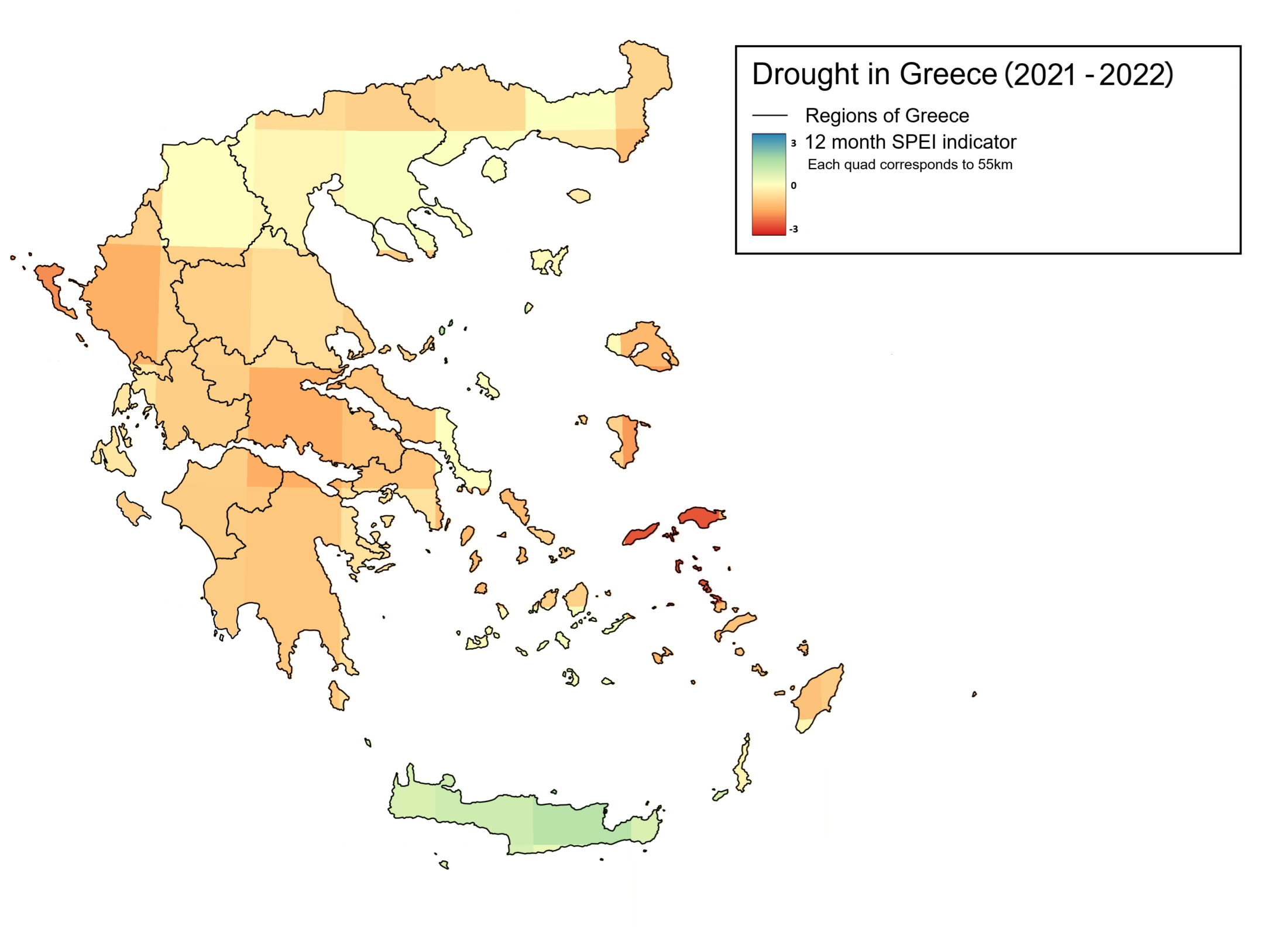
Greece’s climate is becoming increasingly dry by the year. Over the past decade, rainfall has been cut in half. According to the iMEdD analysis using the SPEI (Standardised Precipitation-Evapotranspiration Index, measuring the way plants release water from the soil into the atmosphere), which ranges from 3 to -3, the last three years have consistently shown negative moisture values. In 2023 Greece recorded its lowest value (-1) since 2017.
Prompted by the findings and the map created by the FLAME research project in April 2024, we spoke with Dr. Giannaros who explained, "At the moment, the data we have examined from the European Drought Observatory indicates a significant moisture deficit in the soil, creating very favourable conditions for forest fires. Additionally, if forest fires do occur, the very low soil moisture will be conducive to intense burning, making the fires more severe". The FLAME map shows soil moisture over the past 12 months, an indicator helpful in measuring landscape flammability, particularly in relation to forest fires.
Dr. Giannaros and Dr. Eleftherios Stamatopoulos, a Forestry and Environmental Scientist, were tasked with mapping the areas of increased risk for the summer of 2024. Dr. Giannaros identified a high-risk zone that starts in Evros, runs through the East Aegean islands and Evia, and extends to Attica, Boeotia, Phthiotis, the Peloponnese, the Cyclades, and Crete. These areas have a history of frequent and intense fires.
"I am very concerned about Attica and Chalkidiki in terms of casualties", adds Dr. Stamatopoulos. "These regions have multiple enclosed settlements with a lot of illegal construction. If a fire breaks out there, it will be difficult to manage". North Evia, which burned in August 2021, has shown the first signs of regeneration. "If another fire occurs in North Evia, it will destroy the reforested areas [...] eliminating any chance of further regeneration", he said, confirming that similar risks exist for Evros.

In 2023, the Evros region recorded the lowest SPEI value in mainland Greece, with a drop of 1.3 points - a value influenced by the August fires. Although, individually, the areas of Crete, Attica, Evia and the Peloponnese show a slight improvement in moisture levels over the past year (around 0.2 points), conditions remain concerning as indicated by the FLAME map. "The overall picture we have of this past winter is that it was warm and arid. When we have winters without significant rain and snow, it increases the availability of dead forest fuels", Dr. Giannaros explains, adding that the dying vegetation leaves behind thin and small broken branches, grasses, small shrubs and tree stumps, which dry out and create dead biomass that acts as tinder. "This means that there is material available to burn right now".
intenance, reservoir placement based on water availability, and the creation of firebreaks".
Firefighting is akin to guerrilla warfare
On March 31, 2024, a fire erupted in Pieria, raging for four days. This marked one of the rare instances where fires extended to high altitudes. "It seems to be reshaping the geographical distribution of fires to some extent", says Dr. Giannaros. "We're witnessing a shift towards fires occurring in different ecosystems, at higher elevations. Greece is not familiar with this, especially at this time of year." Dr. Stamatopoulos notes that, historically, fires in Greece have predominantly occurred in lowland and semi-mountainous areas, in what is known as the "Pefki zone". As altitude increases, burning becomes more difficult, as the landscape is (or rather used to be) less dry. "When Pieria burned this year - at an altitude of 1500 metres - no one could bring it under control. It took five whole days, even though altitudes like this are typically manageable if the right methodology is applied. I think we're witnessing a systemic incompetence here".
We're witnessing a shift towards fires occurring in different ecosystems, at higher elevations.
Dr. Thodoris Giannaros, the scientific leader of the FLAME project
According to the Wildfire Peer Review Assessment Framework established by the European Union, the response begins with prevention measures – prior to the fire’s ignition. "When a fire breaks out and temperatures soar to 600 or even 1000 degrees Celsius, the response essentially becomes a form of guerrilla warfare", explains Dr. Stamatopoulos. Reviewing and analysing past fires, reducing risk through public education about actions that could trigger wildfires and ensuring the preparedness of response agencies are pivotal elements that must be addressed before the onset of the fire season.
The most important thing, however, is to understand the forest environment you’re operating in. Forest management, which, as per Dr. Stamatopoulos, has suffered significant setbacks due to insufficient funding, is an essential preparatory step that informs effective fire response strategies. "Without proper management, it's difficult to prioritise protection efforts", he says. "You ensure the removal of excess (vegetation), preserve birdlife habitats […]. Management is the blueprint for determining road construction, maintenance, reservoir placement based on water availability, and the creation of firebreaks".
"Fire, as we now perceive and experience it, has evolved due to changes in the environment brought about by human activities," Dr. Giannaros adds. "We have altered the environment and induced climate change, resulting in the abandonment of rural areas – not only in Greece – leading to a lack of landscape management. Consequently, we find ourselves in a new environment that, regrettably, we have created, and it is excessively wildfire-friendly".
Translation: Anatoli Stavroulopoulou